I’ve recently come across two interesting projects and web sites: openaerialmap.org and openstreetmap.org. These two projects are efforts to collect and share freely-available map information.
One may wonder what the point is, since you can get all kinds of free map tools through the likes of Google Maps, Google Earth, MapQuest, and the like. But although those tools are available at no cost, they have limitations on what you can do with them. Because the underlying data is owned and copyrighted by commercial companies or governments who spend money and manpower surveying and updating the information, you are restricted from copying the data and you are limited in using it for other purposes. In Europe, even the government-created map data is copyrighted and you can’t copy it for your own use. And if you find mistakes, you can’t fix them.
But simply knowing the names of streets and where they are located cannot be copyrighted, and anyone can make their own maps if they want to do so. A futile and daunting proposal for an individual, but what if you could harness other technology like GPS and the Internet?
Like the open-source software movement, there is an open data movement happening. The world is full of data, but making is useful and accessible has been the hard part. The Internet is changing that.
The OpenStreetMap project is working toward making an entire street map of the world, freely accessible to everyone and freely copyable for anyone’s use.
In the United States this doesn’t sound too unusual, since all federally-produced data is by law public domain. The freely-available data from the US Census is not quite accurate, though, and needs corrections. In other countries, it means starting from scratch.
The OpenStreetMap (“OSM”) software infrastructure is designed around the idea of collecting GPS data logs (“GPS tracks”) and then drawing and labeling streets and features on top of them. Where aerial or satellite photos are freely available, they can be used as tracing sources also.
I’ve been working on fixing up the map for my neighborhood. While the vast majority of the streets are there already, many of them are out of alignment or proportion, and recent developments are missing. Although I have had an interest in maps my whole life, this is the first time I’ve been able to make or work on a map that other people may actually find useful. Fun stuff.
Submitted by amillar on Tue, 2008-03-11 15:40
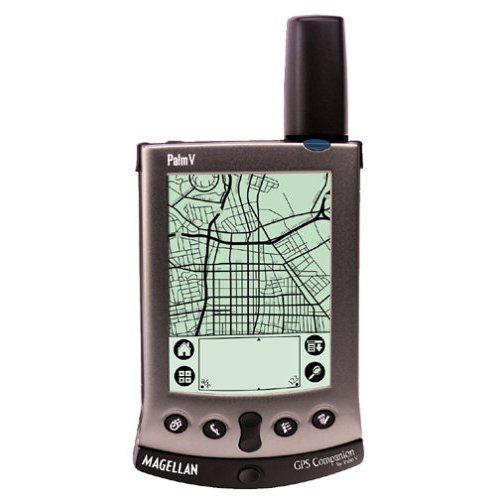 I bought a cheap GPS on EBay. I got a Palm Vx with a Magellan GPS Companion attachment for ten dollars. By PDA standards the Palm Vx is completely obsolete, but it works fine as a GPS data logger.